I’m about halfway through completing my next map for the 5th to 8th nations to be a part of the Southern Union.
Placement
Deciding where to place the new map in relation to the others was quite a simple one. The gap between Le Grout and Günsovölk was the obvious choice for me, so I used the fantastic Azgaar’s Fantasy Map Generator to allow me to create the islands so they look like they broke away from Günsovölk when the tetonic plates were all stuck together. This is something I’d like to flesh out more and provide fault lines and the like, but that’s for another time.

Something that I will rectify is the location of the nations on the world map. They are currently situated far too south for my liking. Le Grout should be more in line with Tasmania or maybe even Cape of Good Hope in South Africa. This would obviously push Koana Islands and Günsovölk further north to become far more tropical. I’m thinking the weather in the north of these nations would be comparable to Florida. It’s something I’ll play around with once the final map is finished.
Height Map
As we are in the middle of the Indian Ocean and my tentative position on any tectonic plate fault lines is along the northern coast of Ianoia, I feel volcanoes should certainly be a part of the islands, but more eastern in location due to the closer proximity of the fault line.
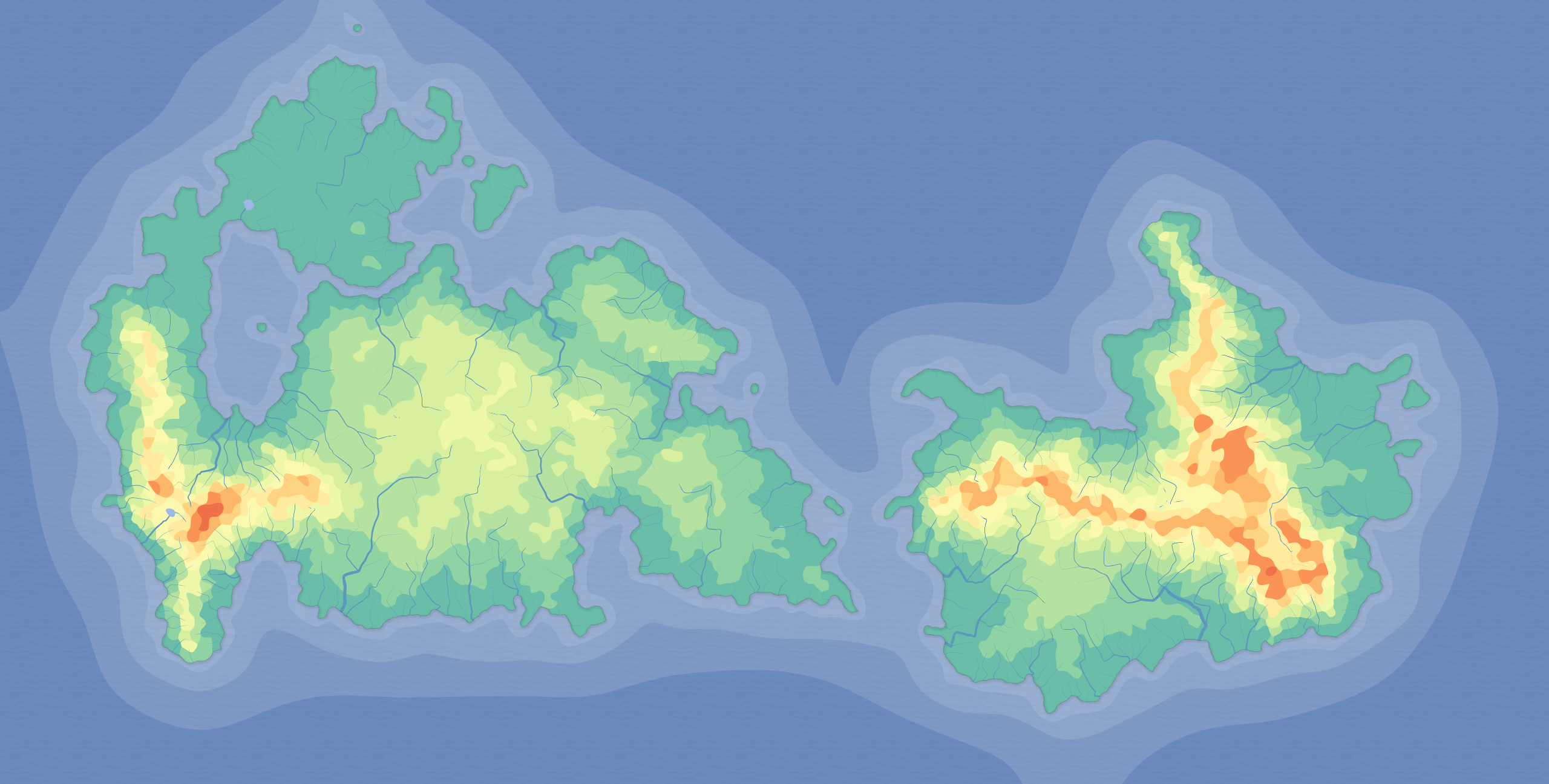
After playing around with the Map Generator it gave me something I liked; two large islands, with the eastern island forming from a cluster of large mountain tops and the southern tip of the western island also showing decent height for my liking.
When placed directly below Günsovölk (albeit roughly and not to scale) you can see how the plates would have broken apart and the landmass would have been millions of years ago, although I’ve never tried to see how the fictional plate would have joined up with Pangea.

Founding and Settlement
Because I’m an idiot, when I created Günsovölk I did a bit of light research into explorers and particularly Dutch explorers who found Indonesia and Australia. History is not my strong point (jack of all trades, master of none and all that) I saw that Willem Janszoon first mapped north Australia and figured being Dutch he must’ve traversed the Indian Ocean in some capacity to serve the Dutch East Indies in what we now know as Indonesia on his way to Australia. What I only discovered lately was Janszoon never actually went west and served the Dutch East Indieshis entire life, traversing around the islands of Indonesia on his way to discovering Australia. Seems implausible that he would’ve sailed east through Indonesia, discovered the northern tip of Australia, and then sailed 3000km west – past the inhabited Koana Islands – to discover Günsovölk.
Upon further reading on Wikipedia (I know, not a reliable source), I learned of Frederick de Houtman, who was part of the First Dutch expedition to East Indies. The voyage was treacherous, and when they reached Madagascar where they were forced to stay for six months, losing 71 men during that time to various illnesses. Therefore, a slight tweak in history (both real and imagined) is in order.
Firstly, rather than just 248 crew on board, the expedition actually also contained double the amount, mostly families with women and children looking to start a new life in the East Indies.
Secondly, rather than going to Madagascar, the boats were forced to head east when they encountered Portuguese ships and they landed on the “new” western island and stayed for 4 months. Many of the families decided to stay, with the voyage carrying on to Kekerdom in Günsovölk where they were again forced to moor off-shore due to illness a few weeks later. Two months later the voyage carried on east as what’s reported in the history books.
This new history means I’ve had to update Günsovölk and its travel guide so that it was in fact discovered by Frederick de Houtman in 1595, rather than Janszoon in 1605. Do research people!
Four Nations
As I’ve always envisaged the Southern Union to contain a rather large number of nations, but finding the space in the Indian Ocean to create huge countries like Ianoia, Koana Islands and Günsovölk is just not feasible anymore, smaller nations seems the go. I also wanted to do something not part of any other map: land borders. Currently, the four “original” nations were all separated by water and I didn’t want that to be the case.
With only two islands to play with, I divided the western island up into three, with two smaller nations and a large one separating the two. That of course leaves just the east island to be one nation on it’s own, divided by sea.
One issue with land borders is they usually aren’t just arbitrarily drawn up, and especially when you look at Europe, many wars were fought to get the lines we now know today. Therefore having land borders poses another problem, why are they located where they are and when.

Names & Background
Knowing I wanted a Dutch-influenced nation on the west coast due to the discovery by Frederick de Houtman, I decided the north-western “pink” nation would be where the expedition set foot onto the islands, namely the two little bays to the north. The cluster of islands would be named the Islands of Duifje (a name of one of the ships on the expedition).
Due to families from the voyage staying behind, I figured calling the nation Houtmansland made the most sense due to their admiration of the explorer. They were initially another state of Günsovölk but gained full autonomy in 1834 due to their stronger ties to the Netherlands compared to Günsovölk and Germany.
Of course, the pink nation shares a border with the larger orange nation on the same island and this is where land borders play a part. I really wanted to have some sort of civil war in the Southern Union, and this was an obvious choice. Zuidgelders was originally part of Houtmansland, but broke away in 1756 over a dispute on taxation from Günsovölk where farmers in the southern part of Houtmansland felt they were being unfairly treated. Ianoia secretly supplied weapons and even men to the farmers’ cause as a way to destabilise Günsovölk’s hold on the island. A 5-year conflict ensued before we end up with the border between the two countries we know today.
Whilst I’m no war historian, it seems obvious to me that there would be pinch-points of sorts, and doing a D-Day style beach landing would not be something that would happen and the poor farmers wouldn’t have had access to large naval ships so fleet battles weren’t really a part of the conflict and therefore the strait located between the two nations didn’t see any shift in ownership despite many “raids” taking place over the years.
It seems logical that the main focus on fighting would’ve been the land-border to the west. That’s where the battle lines shifted the most.


The green nation (we’ll get to the blue/grey one last), is Albaland. This is one I’ve been planning for a long time and has a Scottish background. Ianoia was born from the British Empire in 1632 who formed a colony on the islands on a completely fictional expedition with all crew (including women and children) never returning to Britain. British admiralty assumed the ships as lost at sea and the voyage a failure until 150 years later. Part of the voyage also consisted of many Scottish families who were treated terribly due to the lack of Union between Scotland and England at the time and considered second-class citizens on the boats. After the voyage sailed past Houtmansland the Scottish families were dumped on what is now known as Albaland with the English crew not expecting them to survive on such a mountainous island.
The last nation is Novainsula. When civil war in Houtmansland began in 1756, Ianoia’s involvement with the battle consisted of supplying guns, ammunition and even soldiers to assist the farmers on the agreement that Ianoia would claim the eastern peninsula of the island to effectively surround Albaland and eventually subsume the independent Scottish-influenced state. After the civil war finished in 1761, Ianoia renamed the peninsula Novainsula (Latin for New Island) but by 1802, Ianoia was in the midst of a health crisis with tuberculosis, smallpox, measles, chickenpox, cholera, whooping cough and influenza, among others spreading throughout the country. With little to no military or naval presence in the peninsula after they were called back to help with the medical crisis back home, the locals, sick of being controlled by a government over 1000km away, staged an uprising and took control of state, aided by Zuidgeldans.


All this will be fleshed out more when I get around to doing the travel guides, but for now, that’s enough to whet your appetite. Here’s a few close up shots of the finished bits of the islands:


